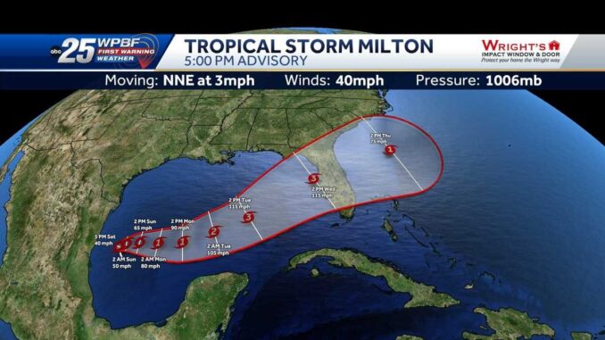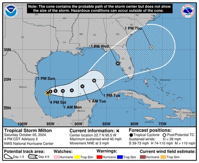
Tropical Storm Milton formed in the Gulf of Mexico on Saturday as forecasters expect the storm to quickly strengthen into a hurricane and trek toward Florida over the next few days.
Milton is expected to develop into a “potentially very impactful hurricane” and hit the Florida peninsula Tuesday or Wednesday, Jamie Rhome, the deputy director of the National Hurricane Center in Miami, said Saturday afternoon during an online briefing.
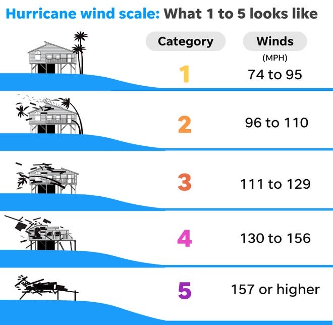
Milton is expected have maximum sustained winds of 115 mph around the time it makes landfall on the Gulf coast of Florida – near St. Petersburg and Tampa. “That’s right on a Category 2-Category 3” hurricane, Rhome said.
Though all hurricanes produce life-threatening winds, hurricanes rated Category 3 and higher are known as major hurricanes. Major hurricanes can cause devastating to catastrophic wind damage and loss of life. Hurricanes of all categories can produce deadly storm surge, rain-induced floods and tornadoes.

Winds from Milton could get as high as 120 mph to 140 mph at landfall and “that will cause structural damage,” AccuWeather senior meteorologist Bob Smerbeck said in a Saturday afternoon briefing.
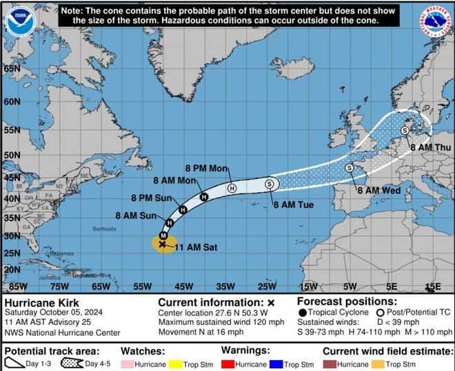
Meanwhile, Hurricane Kirk is expected to generate swells in the Atlantic Ocean affecting the East Coast of the U.S. this weekend, according to the National Hurricane Center.

Milton forecast to hit Florida with heavy rain
No evacuations have been ordered, Rhome said, but they may be necessary. Residents in the Florida peninsula should have their hurricane plan in place, the center said, and follow subsequent forecasts and official notices.
“Regardless of where the storm tracks, it’s going to produce a large area of heavy rain and potential flooding,” Rhome said.
Rapid strengthening is expected as the system moves across the central and eastern part of the Gulf with a hurricane forming around Sunday evening. The west coast of the Florida peninsula can expect life-threatening storm surge and winds beginning late Tuesday or Wednesday – less than two weeks after Hurricane Helene brought devastation to the Southeast.
“People in cities that are still reeling from the record storm surge produced by Hurricane Helene will once again face a significant risk for storm surge flooding and coastal inundation, flooding rainfall, damaging wind gusts and lengthy power outages,” said Brandon Buckingham, a meteorologist with AccuWeather, in an update Saturday. “The potential for rapid intensification is certainly a risk that AccuWeather meteorologists are monitoring very closely.”
Milton may also bring dangerous storm surge, spin-up tornadoes and cause power outages, according to AccuWeather, which warned of high risks to lives and property in Tampa, Fort Myers and other cities along the Gulf coast and parts of central Florida.
On Friday, forecasters were especially worried about torrential rainfall from the system.
As the storm makes landfall and tracks northeast, rainfall of 8-12 inches is expected with an AccuWeather Local StormMax of 30 inches.
As the storm moves northward, central and southern Florida will likely face “tornado risk,” while southern Georgia and South Carolina may get winds of 40 mph to 60 mph, Smerbeck said. “So this could hamper some recover efforts for people getting back on track” after Helene, he said.
Tropical Storm Milton spaghetti models
Illustrations include an array of forecast tools and models, and not all are created equal. The hurricane center uses only the top four or five highest performing models to help make its forecasts.
Hurricane Kirk swells to hit US East Coast
Kirk was located about 1000 miles northeast of the Northern Leeward Islands and its swells are expected to spread westward to the U.S. East Coast, Atlantic Canada, and the Bahamas Saturday night and Sunday, and to the Azores on Monday, the hurricane center said Saturday. The swells are likely to cause life-threatening surf and rip current conditions, the NHC said.
The storm, which is moving north-northwest about 16 mph, is expected to remain a hurricane for the next several days, but will weaken as it makes a turn toward the northeast on Sunday, the NHC said.

If path tracker and spaghetti models are not displaying on your screen, you can view them here.
Leave a Reply
You must be logged in to post a comment.